
Why in News
- Indian Tsunami Early Warning Centre (ITEWC) confirmed that there is no tsunami threat to India following the Tsunami in Japan.
What is a tsunami?
- Tsunami (a Japanese word that means “harbor wave”) is a series of giant ocean waves caused by either earthquakes or volcanic eruptions under the ocean.
- The formation of a tsunami can depend on various factors such as shape of the ocean floor, the distance from the epicenter to coastal areas & direction and the local geography.
- Tsunami’s speed depends on the depth of the water it is traveling through. The deeper the water; the faster the tsunami.
Causes of Tsunami
- Earthquake: When an earthquake occurs under the ocean, a large chunk of the ocean floor suddenly move upward or downward, which leads to a sudden displacement of a large volume of water, thereby causing tsunami waves.
- Volcano eruption: When a volcano erupts in the ocean, the lava flowing out of the volcano displaces the water around it and that water can become a large wave.
How are tsunamis detected?
- Seismic Networks: When an earthquake occurs, seismic networks provide information about an earthquake’s location, depth, magnitude, and other source characteristics.
- The warning centers analyze this information to determine if the earthquake could have generated a tsunami and if a tsunami message is necessary.
- Tide Gauges: Measure the changes in sea level. A sudden and abnormal rise or fall in sea level can indicate the presence of a tsunami but tide gauges alone are not sufficient for giving early warning because it only confirm when tsunami has reached the coast.
- Buoy Networks: Deep-ocean tsunami detection buoys are deployed in the open ocean to detect the characteristic wavelength and height of a tsunami.

- Seafloor Pressure Sensors: These sensors are placed on the ocean floor to detect changes in water pressure and can provide real-time data to help assess the tsunami threat
- Satellite Technology: used to monitor the Earth’s surface and can provide valuable information
- Computer Models: Numerical models are used to simulate and predict tsunami propagation based on data from seismic sensors, buoys, and other sources
- Early Warning Systems: Once a potential tsunami is detected, early warning systems are activated to disseminate alerts to coastal communities.
- Water-Level Networks: If an earthquake meets certain criteria, the warning centers turn to water-level information, looking for changes in water-level height that could indicate the existence and size of a tsunami.
- The primary sources of information about water-level change are a network of Deep-ocean Assessment and Reporting of Tsunami (DART) systems and an extensive array of coastal water-level stations.
- The Pacific Tsunami Warning Center (PTWC) and other regional tsunami warning centers play a crucial role in monitoring and disseminating information about potential tsunamis.
Consequences of Tsunami
Tsunamis can have devastating consequences, causing widespread destruction and loss of life.
- Loss of Life and Injury: Tsunamis can cause significant loss of life, especially in densely populated coastal regions.
- In 2011, Japan was hit by a 9.0 magnitude earthquake and a resulting tsunami which killed around 18,000 people
- Major Accidents: The 2011 tsunami in Japan led to a nuclear meltdown at the Fukushima power plant, causing one of the most severe nuclear accidents.
- Displacement of Communities: People living in coastal areas are forced to evacuate or relocate which can lead to temporary or long-term homelessness and strain on resources.
- Infrastructure Disruption: Tsunamis can damage critical infrastructure such as roads, bridges, ports, and utilities, disrupting transportation and communication networks.
- Economic Impact: Disruption to industries such as fisheries, tourism, and agriculture.
- Contamination of Water Supplies: freshwater sources with saltwater, rendering them undrinkable.
- Environmental Impact: Erosion of coastal habitats, damage marine ecosystems, and deposition of debris and sediment in coastal areas.
- Social and Psychological Impact: The trauma and psychological impact of a tsunami can be long-lasting. Survivors may experience post-traumatic stress
- Impact on Global Trade and Supply Chains
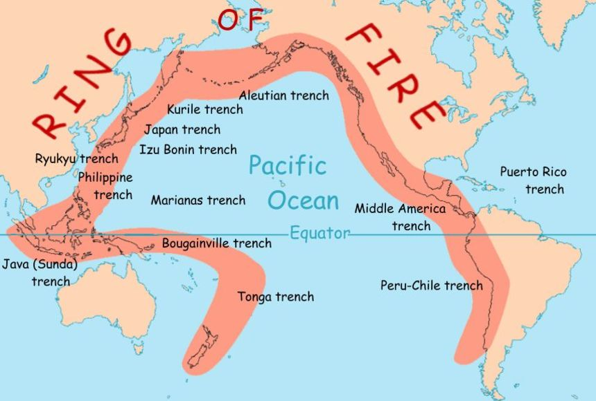
Why is Japan prone to earthquakes and tsunamis?
- Japan is located in a seismically active region of the world due to its position on the Pacific Ring of Fire. The Pacific Ring of Fire is a horseshoe-shaped zone around the Pacific Ocean basin here large number of volcanic event and earthquake occur.
- Within the Ring of Fire, there are different tectonic belts, including the Pacific Plate, Eurasian Plate, and Indo-Australian Plate, which keep meshing and colliding with each other, causing earthquakes, volcanic eruptions and tsunamis.
- Tectonic Plate Boundaries: Japan situated at the convergence of four major tectonic plates—the Pacific Plate, Philippine Sea Plate, Eurasian Plate, and North American Plate.
- The Japanese archipelago has numerous active volcanoes, and the movement of magma beneath the Earth’s crust contributes to the seismicity of the region.
- Megathrust Earthquakes: The subduction of the Pacific Plate beneath the North American Plate in the Japan Trench lead to megathrust earthquakes which are the largest and most powerful earthquakes in world, capable of producing devastating tsunamis.


Due to these geological factors, Japan always faces a higher risk of earthquakes and tsunamis. The Japanese government has implemented strict building codes, early warning systems, and disaster preparedness measures to mitigate the impact of seismic events.
Challenge before Bharat Regarding Tsunami
India encounters numerous obstacles concerning tsunamis given its vast shoreline along the Indian Ocean. Even though the Bay of Bengal and the Arabian Sea are not as prone to seismic activity as the Pacific Ocean, they remain vulnerable to tsunamis triggered by earthquakes. Below are a few of the hurdles that India faces regarding tsunamis:
- Tectonic Activity: India is located near the boundary of the Indian Plate and the Eurasian Plate. Subduction zones and plate interactions in the Indian Ocean region can potentially trigger undersea earthquakes, leading to tsunamis. Example – 2004 Indian Ocean tsunami
- Population Density
- Lack of Public Awareness: Many of India’s coastal areas are densely populated, with major cities and towns located near the coast.
- Infrastructure Vulnerability: Coastal infrastructure, including residential buildings, commercial establishments, and critical facilities, may not always be designed or constructed to withstand the forces of a tsunami.
- Early Warning Systems: While India has made significant progress in developing and implementing early warning systems, there are ongoing challenges especially in remote areas
- Coordination and Communication: Tsunami preparedness requires effective coordination among various agencies, including meteorological departments, disaster management authorities, and local governments.
- Climate Change and Sea Level Rise:
- Evacuation Challenges: need to move large populations to safer locations require careful planning.
| About Indian National Centre for Ocean Information Services (INCOIS) – An autonomous body under the Ministry of Earth Sciences (MoES) and is a unit of the Earth System Science Organisation (ESSO). – ESSO-INCOIS established in 1999 under the Ministry of Earth Sciences (MoES), located in Hyderabad. – Indian Tsunami Early Warning Centre (ITEWC) is also housed in the INCOIS. – Mandate: To provide the ocean information and advisory services to society, industry, government agencies and scientific community through sustained ocean observations and systematic and focussed research. |